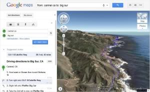
Getting directions is one of the most popular features on Google Maps, whether it be for driving, walking, biking or transit. Google launching a new feature that allows you to bring your upcoming trip to life, by allowing you to preview your route in 3D.
This feature allows online navigators to visualize any driving, walking or mass transit route with a 3D, bird's-eye animation. All you have to do is enter your starting point, destination and mode of transportation, and click the new "3D" button that will appear next to each route. From there, you'll be launched into a Google Earth-powered flight, displaying all the buildings, mountains and other terrain that you'd encounter during your real-life journey.
You can also pause the flight at any moment to check out any sights of interest, along with any geo-linked photos, videos or other online content.
For more introducing, just click to look what you wanna be to know 'bout Google Maps 3D in Google LatLong
No comments